


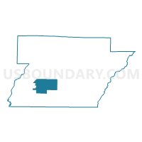
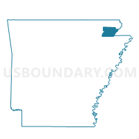
Cache Voting District, Greene County, Arkansas
About
Outline

Summary
| Unique Area Identifier | 526575 |
| Name | Cache Voting District |
| County | Greene County |
| State | Arkansas |
| Area (square miles) | 21.92 |
| Land Area (square miles) | 21.87 |
| Water Area (square miles) | 0.05 |
| % of Land Area | 99.77 |
| % of Water Area | 0.23 |
| Latitude of the Internal Point | 36.05715580 |
| Longtitude of the Internal Point | -90.66475600 |
Maps

Graphs
Select a template below for downloading or customizing gragh for Cache Voting District, Greene County, Arkansas


Neighbors
Neighoring Voting District (by Name) Neighboring Voting District on the Map
- Bryan Voting District, Greene County, AR
- Poland Voting District, Greene County, AR
- Salem Voting District, Greene County, AR
- Spring Grove Voting District, Greene County, AR
- Sugar Creek Voting District, Greene County, AR
Top 10 Neighboring County Subdivision (by Population) Neighboring County Subdivision on the Map
- Spring Grove township, Greene County, AR (7,180)
- Poland township, Greene County, AR (1,486)
- Cache township, Greene County, AR (1,184)
- Salem township, Greene County, AR (965)
- Sugar Creek township, Greene County, AR (729)
- Bryan township, Greene County, AR (192)
Top 10 Neighboring Unified School District (by Population) Neighboring Unified School District on the Map
Top 10 Neighboring State Legislative District Lower Chamber (by Population) Neighboring State Legislative District Lower Chamber on the Map
- State House District 78, AR (31,051)
- State House District 73, AR (26,277)
- State House District 79, AR (24,175)